Showing posts with label Easter Walk 2011. Show all posts

Sunday, 1 May 2011

Easter Walk '11: Old Leigh

Old Leigh
(Click on the photo for more pictures at the flickr site)
So the final stop in the Easter Walk was the sea front at Leigh on Sea, better known as Old Leigh. Rows of cockle sheds give way to pubs, restaurants and the like in what is probably my favourite place in Essex. I'm not going to write too much about it now, but will most definitely be returning later in the year.

The Crooked Billet, Old Leigh

One of the main events hosted in Old Leigh is the Leigh Folk Festival which bills itself as the largest free folk festival in England. It's a tremendous event, particularly the sunday which features a parade of dance sides at lunch time, followed by an afternoon of music on stages outside most of the pubs.

They were hosting a fund-raising event in Southend to which I ventured, seeing acts like Pancho and Lefty, and The Famous Potatos (pictured below).

CIMG1731

Friday, 29 April 2011

Easter Walk '11: Hadleigh Castle

Hadleigh Castle  Hadleigh Castle
(Click on the photos for more pictures at the Flickr site)

Hadleigh Castle was originally built in the 1230s by Hubert de Burgh who was Justiciar (chief minister) under King John. Shortly after its completion, de Burgh had a falling out with the King and was imprisoned with the castle falling into royal hands. It was only in the mid 14th century, during the 100 years war that it achieved noted importance as a potential defence against French invasion. Edward III initiated an extensive rebuilding project during which most of what remains today was constructed. As the threat of invasion faded, the castle fell from popularity and was eventually sold to Lord Riche in 1551 who sold off building materials.

Hadleigh Castle

On the face of it, this is an ideal location for a castle, a ridge of high ground affording excellent views of the Thames estuary. Unfortunately, the ground was unstable and as early as 1274 problems with subsidence and slippage were recorded. Below the standing remains shown in the photos can be found sections of masonry that have slipped down the slope.

Thursday, 28 April 2011

Easter Walk '11: The Battle of Benfleet

St Mary the Virgin, Benfleet  Statue Marking the Battle of Benfleet
(Click on the photos for more pictures at the flickr site)

In 893 England was largely split in two. Alfred and his men had emerged from their hideaway in Athelney and occupied the west of the country, whilst the eastern half was Danelaw, ruled by Vikings. A large force of Vikings, under Haesten had made their base at Benfleet, where the creek would have made a natural harbour for them to land their boats. Haesten and his men used Benfleet as a launch point for raiding parties, and it was whilst the bulk of the force were out on one such excursion that Aethelred and a force of local militia (mostly from London) and other fighting men attacked.

With the bulk of the Viking army seemingly away, they won a comfortable victory, sacking the Viking base, burning their ships and carrying off hostages. The Anglo-Saxon chronicle, which is the best source for the battle tells that amongst the captives were Haesten's family, including his sons, one of whom was King Alfred's godson (one of the conditions of a previous truce had been that Haesten and his family had been baptised with Alfred and Aethelred amongst the godparents).

Following the battle, and the destruction of his ships, Haesten and his party retreated to Shoebury to lick their wounds, before venturing northwest into the kingdom of Mercia.

Benfleet Creek

When the navvies were building the railway line (just visible to the right of the above photo), they uncovered burnt timbers which are believed to be the remains of some of Haesten's boats. Following the battle, Alfred gave orders for a church to be built in thanks for the victory. St Mary The Virgin, Benfleet (top left) stands on the site of that original church, and Alfred is commemorated in its stained glass window. The site of the battle has never been formally identified, although it seems likely that it is near where the station is today. A statue, representing a dragon boat, stands near the believed site.

Wednesday, 27 April 2011

Easter Walk '11: St Margaret's Bowers Gifford

St. Margaret's, Bowers Gifford
(Click on the photo to see more pictures at the Flickr site)

First stop on the walk was the St Margaret's church, Bowers Gifford. Although there may have been an earlier church here, the stone-built one has it's origins in the early 14th century when it was built by the lord of the manor, Sir John Giffard. As is always the case with churches of this age, it shows the signs of a number of modifications over the years including the tudor bell tower (the bells are apparently still the original 14th century ones).

The thing that I don't understand is why the church is where it is. Looking at the OS map, it is on an area of low ground and in the 14th century would probably have been uncomfortably close to the marshes. It is some distance from the location of the manor house, whilst the present day village of Bowers Gifford is further away still. Perhaps the medieval village was in a different location, or perhaps Giffard didn't want to use prime land for the building of the church?

Monday, 25 April 2011

Easter Walk '11

Hadleigh Castle  Statue Marking the Battle of Benfleet

On Easter Saturday / St Georges Day, I forewent the pleasures of decorating for an exploration of what might loosely be described as "my patch". This week, I'll be posting a short series of posts talking about what I saw, but for now here is the route I followed. If you want to do something similar, it's mostly straightforward footpaths, although the section just east of the A130 is stiles through fields, and Hadleigh Country Park is quite hilly in places.

I started at the base of St Michaels Mount, picking up the footpath towards St Margarets Bowers Gifford. The signage was less than clear, and the footpath initially quite narrow, squeezed between the back gardens of a row of houses and the railway fence.

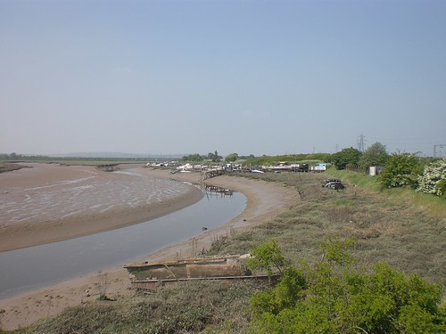
Once clear of the houses, the path opens up into an area of mostly low lying scrubland. The path follows alongside the railway line (Pitsea to Southend on C2C) all the way to St Margaret's church where I paused for a drink of water.

After the church, the path continues alongside the railway line until veering off to pass under the A130 (Canvey Way). Immediately after the A130, the path is less well defined, taking you through a series of small fields which contained horses. A series of stiles enables the crossing of the fences.

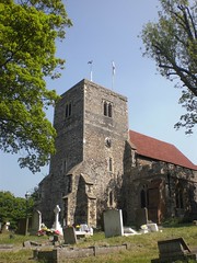
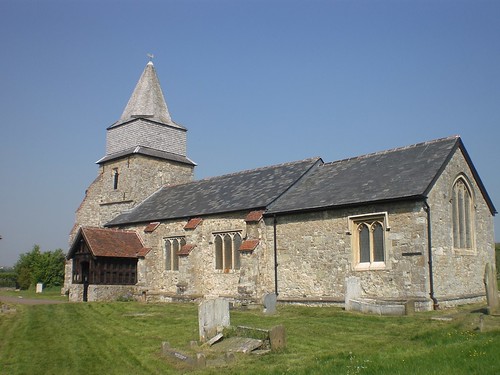
On leaving the farm, the path narrows again, passing behind some houses before entering an area of parkland in Benfleet, and then the town itself. I took a small detour to visit the Church of St Mary the Virgin and then had lunch in a pub, The Half Crown.

Leaving the station on my right, I walked up Station Road before picking up the path from the top of the road. The route then enters Benfleet Downs, and then Hadleigh Country Park.

There are any number of routes through the country park, but not all of the area is publicly accessible - there is a rare breeds center there, amongst other privately owned land, so check your paths on an OS map would be my advice.

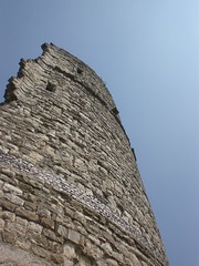
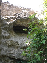
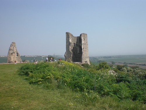
I took in a stretch of the Olympic 2012 Mountain Biking course, before reaching the ruins of Hadleigh Castle, a popular local picnic spot.

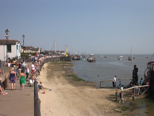
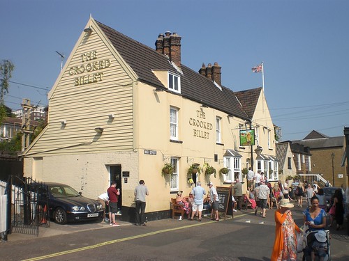
After a short rest stop, I picked up the path towards Leigh On Sea, running more or less straight although for some reason one part was diverted along the edge of a field. At Leigh station I headed down the steps to walk behind the cockle sheds, eventually reaching the Crooked Billet. Pint purchased, I got a 1/2 pint of whelks from the stall and sat on the edge of the sea wall.

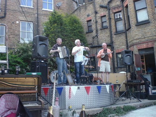
A short train ride to Southend Central later, and I found myself in the Railway Hotel, pint in hand watching bands playing a St Georges Day fundraiser for Leigh Folk Festival.